1. ViaMichelin http://www.viamichelin.fr/web/ItineraryPrint
Itinéraire imprimé le14/04/2010
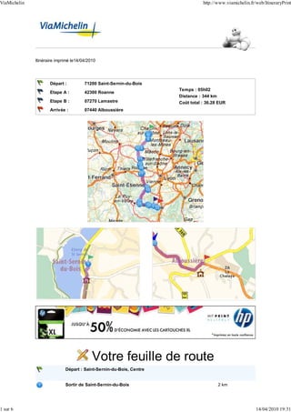
Départ : 71200 Saint-Sernin-du-Bois
Temps : 05h02
Etape A : 42300 Roanne
Distance : 344 km
Etape B : 07270 Lamastre Coût total : 36.28 EUR
Arrivée : 07440 Alboussière
Votre feuille de route
Départ : Saint-Sernin-du-Bois, Centre
Sortir de Saint-Sernin-du-Bois 2 km
1 sur 6 14/04/2010 19:31
2. ViaMichelin http://www.viamichelin.fr/web/ItineraryPrint
2 km 00h04
Continuer sur : Chemin de la Navière 0.4 km
2.5 km 00h05
D61 Prendre à droite : D61 5 km
Virage à droite 3 km 00h05
7.5 km 00h10
Traverser Marmagne 1.2 km
Continuer sur : D61 / Route des Grands Champs (0.7 km)
Prendre à gauche : N80 / Route du Bois de Ruault (0.6 km)
Sortie de Marmagne
8.5 km 00h12
N80 Prendre N80 4 km
Succession de virages sur 0.7 km 8.5 km 00h12
13 km 00h16
Traverser Montcenis 2.5 km
Continuer sur : N80 (<0.1 km)
Prendre à droite : D980 (2.5 km)
Succession de virages sur 3.5 km 15 km 00h20
Sortie de Montcenis
15 km 00h20
D980 Prendre D980
11 km
26 km 00h31
N70 A Blanzy, Prendre à droite : N70 / E607 en direction de : 34 km
E607 MOULINS
ROANNE
MONTCEAU-CENTRE
MÉMORIAL A.F.N.
60 km 00h56
Continuer sur : N79 / E607 / E62 11 km
N79
Prendre sortie en direction de : 70 km 01h02
E607
SORTIE 23
ROANNE
GUEUGNON
DIGOIN-CENTRE
71 km 01h03
D982 Au rond-point, prendre la 3ème sortie Continuer sur : D982 en direction 34 km
de :
ROANNE
Traversée de Le Bois de La Motte 72 km 01h04
Succession de virages sur 1.1 km 79 km 01h11
RADAR : D982 borne km 29.3 (90 km/h), au niveau de Saint- 99 km 01h29
Martin-du-Lac.
105 km 01h36
2 sur 6 14/04/2010 19:31
3. ViaMichelin http://www.viamichelin.fr/web/ItineraryPrint
D482 Continuer sur : D482 15 km
Traversée de Briennon 105 km 01h36
RADAR : D482 borne km 6.4 (50 km/h), au niveau de Pouilly- 111 km 01h42
sous-Charlieu.
120 km 01h52
Entrer dans Roanne 4 km
Continuer sur : Rue de Charlieu (3.5 km)
Continuer sur : Avenue de Lyon (0.1 km)
Prendre à gauche : Rue Alexandre Roche (0.2 km)
Prendre Place Georges Clemenceau (<0.1 km)
Continuer sur : Place du Maréchal de Lattre de Tassigny (0.1 km)
Continuer sur : Rue du Château (<0.1 km)
Prendre à gauche : Rue des Aqueducs (0.1 km)
Prendre à gauche : Rue de Cadore (0.1 km)
125 km 02h02
Etape A : Roanne, Centre
125 km 02h02
Sortir de Roanne 1.8 km
Prendre à gauche : Rue Charles de Gaulle (<0.1 km)
Continuer sur : Place Georges Clemenceau (0.2 km)
Prendre à droite : Rue de Fontenille (0.4 km)
Continuer sur : Rue de l'Hôpital (0.3 km)
Prendre à gauche : D482 / Boulevard Bernard Palissy (0.3 km)
Prendre D482 / Rue de Charlieu (0.7 km)
Sortie de Roanne
126 km 02h07
Prendre à gauche : N7 en direction de : 10 km
N7 SAINT-ETIENNE
CLERMONT-FERRAND
LYON
CHEMIN GARDET
137 km 02h14
Prendre N82
N82 16 km
Virage à droite 150 km 02h22
Virage à droite 153 km 02h24
153 km 02h25
Continuer sur : A89 5.5 km
A89
Nervieux : Prise de ticket 157 km 02h26
Suivre la direction : 157 km 02h27
A72
SAINT-ETIENNE
LYON
158 km 02h28
Continuer sur : A72 / E70 45 km
3 sur 6 14/04/2010 19:31
4. ViaMichelin http://www.viamichelin.fr/web/ItineraryPrint
A72
E70 Veauchette : Péage : 3.40 EUR 190 km 02h44
Prendre sortie en direction de : 203 km 02h51
SORTIE 10
FIRMINY
LE PUY
ANNONAY
VILLARS
SAINT-ETIENNE-BELLEVUE
HÔPITAL-NORD
Suivre la direction : 203 km 02h51
FIRMINY
LE PUY
ANNONAY
SAINT-ETIENNE-BELLEVUE
VILLARS
203 km 02h51
A proximité de Saint-Étienne, Continuer sur : D201 en direction de : 10 km
D201 VILLARS-OUEST
Suivre la direction : 213 km 02h59
N88
FIRMINY
LE PUY
LE CHAMBON-FEUGEROLLES
214 km 02h59
Continuer sur : N88 49 km
N88
RADAR : N88 borne km 4.7 (90 km/h), au niveau de 228 km 03h11
Pont-Salomon.
Descente dangereuse sur 0.6 km 228 km 03h11
Descente dangereuse sur 0.5 km 235 km 03h15
Descente dangereuse sur 0.6 km 252 km 03h27
263 km 03h35
Traverser Le Pertuis 1.6 km
Continuer sur : N88 (0.7 km)
Prendre à gauche : D28 (0.9 km)
Succession de virages sur 3.5 km 264 km 03h36
Sortie de Le Pertuis
265 km 03h37
D28 Prendre D28 5.5 km
Succession de virages sur 1 km 269 km 03h42
270 km 03h43
Traverser Saint-Julien-Chapteuil 2.5 km
Continuer sur : D28 (1.4 km)
Au rond-point, prendre la 3ème sortie Continuer sur : D15 (1.1 km)
Sortie de Saint-Julien-Chapteuil
273 km 03h47
D15 Continuer sur : D15
27 km
4 sur 6 14/04/2010 19:31
5. ViaMichelin http://www.viamichelin.fr/web/ItineraryPrint
Succession de virages sur 4 km 273 km 03h47
Succession de virages sur 1.1 km 278 km 03h53
Descente dangereuse sur 1.2 km 282 km 03h56
Virage à droite 284 km 03h58
Descente dangereuse sur 0.7 km 285 km 03h59
Vous roulez depuis environ 2 heures, pensez à faire une pause.
Virage à gauche 295 km 04h08
300 km 04h12
D120 Prendre D120 2.5 km
Succession de virages sur 0.4 km 302 km 04h14
303 km 04h15
Traverser Saint-Agrève 0.9 km
Prendre D120 (0.5 km)
Au rond-point, prendre la 1ère sortie Continuer sur : D120A (0.4 km)
Sortie de Saint-Agrève
303 km 04h16
D120A Prendre D120A 0.3 km
304 km 04h16
Traverser Saint-Agrève 1.7 km
Prendre D120A (1 km)
Continuer tout droit (<0.1 km)
Au rond-point, prendre la 2nde sortie Continuer sur : D533 (0.6 km)
Descente dangereuse sur 1.7 km 305 km 04h17
Sortie de Saint-Agrève
305 km 04h18
D533 Prendre D533
18 km
Succession de virages sur 12 km 305 km 04h18
Descente dangereuse sur 2.5 km 307 km 04h20
Succession de virages sur 0.3 km 319 km 04h33
Succession de virages sur 3 km 320 km 04h34
324 km 04h38
Entrer dans Lamastre 1.5 km
Continuer sur : D533 (1.3 km)
Prendre à gauche : Place Charles Seignobos (0.1 km)
Continuer sur : Place de la République (<0.1 km)
Continuer sur : Place des Frères de Montgolfier (<0.1 km)
325 km 04h41
Etape B : Lamastre, Centre
325 km 04h41
Sortir de Lamastre 2 km
Prendre Place des Frères de Montgolfier (<0.1 km)
5 sur 6 14/04/2010 19:31
6. ViaMichelin http://www.viamichelin.fr/web/ItineraryPrint
Prendre à gauche : Place de la République (<0.1 km)
Prendre à gauche : Place Charles Seignobos (0.1 km)
Prendre à gauche : D533 / Rue Désiré Bancel (0.1 km)
Prendre à droite : Rue Jules Ferry (0.3 km)
Prendre à droite : Grand-Rue de Macheville (0.2 km)
Prendre à droite : D533 (1.2 km)
Succession de virages sur 4.5 km 326 km 04h44
Sortie de Lamastre
327 km 04h45
D533 Continuer sur : D533
16 km
Succession de virages sur 11 km 332 km 04h50
Descente dangereuse sur 2.5 km 339 km 04h57
343 km 05h01
Entrer dans Alboussière 0.8 km
344 km 05h02
Arrivée : Alboussière, Centre
344 km 05h02
6 sur 6 14/04/2010 19:31